What the Pacific Is Telling Us About Summer 2026 in Texas
The Pacific is running hot and El Niño is showing up early. Here is what that probably means for the Hill Country rivers between now and Halloween.
If you're the kind of Texan whose summer revolves around a tube on the Comal, an inner-tube run down the Frio, or a Saturday float on the Guadalupe with a cooler and three of your cousins, this season is shaping up to be a little different from the last few. The same applies if you drive in once a year from Houston or Dallas just to put your feet in cold water. The river you remember is not necessarily the river you'll get, because the Pacific Ocean changed its mind, and that always has a way of showing up in Texas.
July 4 of last year is the proof. Six and a half inches of rain over three hours up at Hunt sent the Guadalupe to a record 37.52 feet, and 139 people were dead by the end of the week. That kind of morning is what we want to be ahead of.
The Pacific is talking
For most of the last six years, La Niña ran the show. Drought, hot afternoons, a stubborn ridge over Texas. That's flipping. The Climate Prediction Center has us in ENSO-neutral right now, but the eastern equatorial Pacific is warming up so fast the forecasters are calling for El Niño to settle in by midsummer and stick around through the end of the year, with probabilities running 88 to 94 percent.
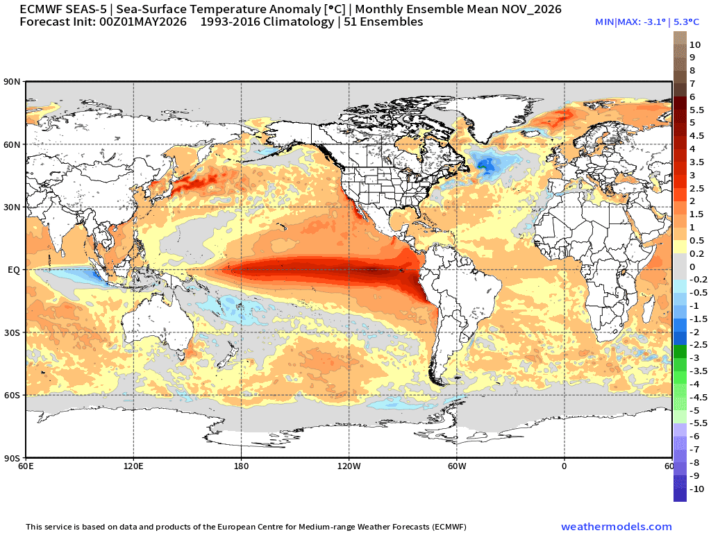
The hero image up top is the European model's sea-surface temperature forecast for late 2026. The wide red band across the equator is what an El Niño looks like before it shows up in your weather report. The chart below is the actual measured anomaly, and you can see how fast the four Niño regions flipped from cool to warm this spring.
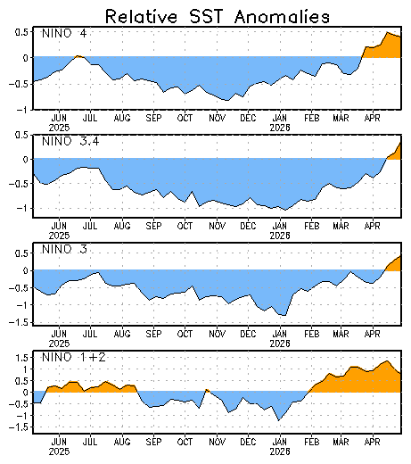
That spike on the right side is the ocean changing its mind.
What it means for summer and fall
Two things, mostly.
First, the Atlantic hurricane season is likely a touch quieter than average. Colorado State's April outlook is calling for thirteen named storms, six hurricanes, two majors, against long-term averages of fourteen, seven, and three. The reason is that El Niño cranks up upper-level wind shear over the tropics, and shear pulls hurricanes apart before they can wind up. CSU put the odds of a major hurricane making landfall on the Texas-to-Florida Gulf Coast at twenty percent this year, against a long-term average of twenty-seven. So a little less to worry about from named storms.
Second, and this is the part river folks ought to pay attention to, El Niño does not need a hurricane to put water on the Hill Country. With both the Pacific and the Gulf running warmer than normal, the atmosphere over Texas is going to be loaded with moisture all summer. That's the fuel for the slow-moving afternoon thunderstorms and mesoscale clusters that park themselves over the Edwards Plateau and dump four, six, eight inches in a hurry. The diagram below shows the storm track that El Niño tends to drag south across our part of the country. Once that pattern locks in this fall, every passing system has a better chance of squeezing rain out over Texas instead of sliding north of us.
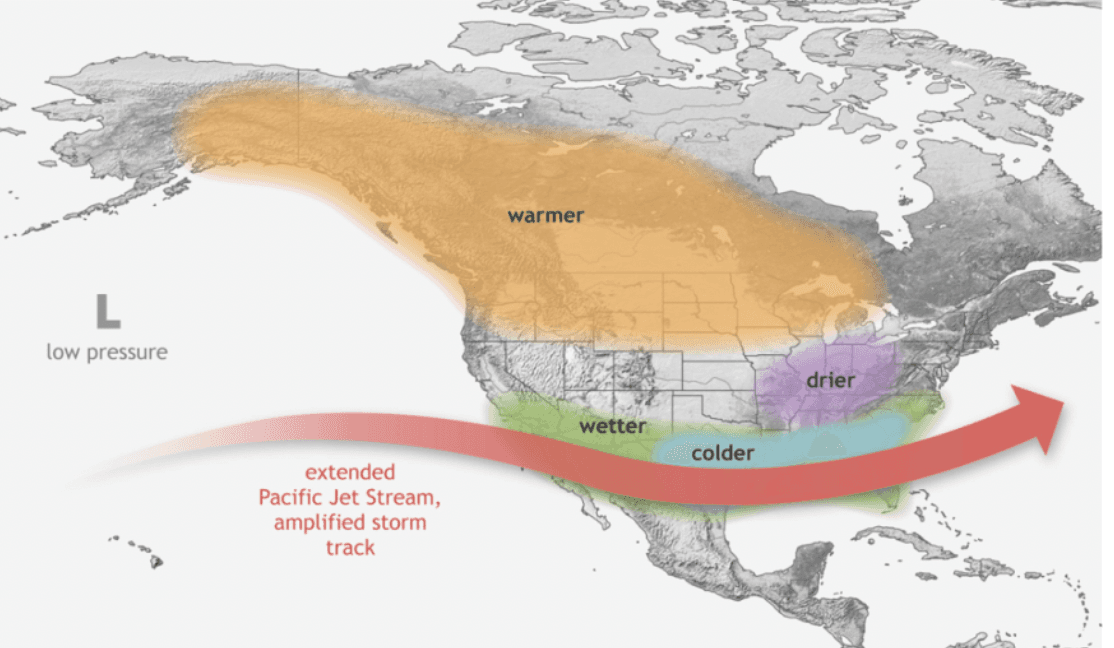
The San Antonio Express-News ran a recent piece on this same setup. The short version is, when the jet dives south, the Hill Country, the coast, and the Big Bend all see more days with measurable rain than they would in a La Niña year.
Why the rivers go from quiet to deadly
The Edwards Plateau is mostly limestone with a thin layer of soil. When a heavy rain hits, the ground can't soak up much, so most of it runs off. The drainages are steep and they funnel that runoff into narrow channels: the Guadalupe, the Comal, the Blanco, the Llano, the Frio. Six inches of rain over three hours upstream of Hunt produced a thirty-seven-foot crest because the water didn't have anywhere else to go. The National Weather Service has called this country "Flash Flood Alley" for years, and the per-capita flood death rate here is one of the highest in the country.
What to do about it
Watch the gauges upstream of where you're at, not just the one at your spot. By the time the river is climbing under your feet, your decision time is gone. The map at the explorer page shows every gauge we track. The per-river pages, like the Guadalupe, include trend charts so you can see whether things have been climbing.
Don't drive across a flooded low-water crossing. Six inches of moving water can take a person off their feet, two feet will move most cars. And if you're floating, fishing, or camping, know which way is uphill from where you sleep.
The river is going to be the river. The Pacific is just turning the volume up. Respect it, check before you put in, and tell somebody where you'll be. If something on this site is wrong or missing, drop us a line.